Английский (топики / темы): The Geographical Position of Great Britain — Географическое положение Великобритании (3)
The Geographical Position of Great Britain (3)
The United Kingdom of Great Britain and Northern Ireland covers an area of some 244 thousand square miles. It is situated on the British Isles. The British Isles are separated from Europe by the Strait of Dover and the English Channel. The British Isles are washed by the North Sea in the east and the Atlantic Ocean in the west.
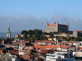
The population of Great Britain is about 60 million. The largest cities of the country are London, Birmingham, Liverpool, Manchester, Glasgow and Edinburgh.
The territory of Great Britain is divided into four parts: England, Scotland, Wales and Northern Ireland.
England is in the southern and central part of Great Britain. Scotland is in the north of the island. Wales is in the west. Northern Ireland is situated in the north-eastern part of Ireland.
England is the richest, the most fertile and most populated part in the country. There are mountains in the north and in the west of England, but all the rest of the territory is a vast plain. In the northwestern part of England there are many beautiful lakes. This part of the country is called Lake District.
Scotland is a land of mountains. The Highlands of Scotland are among the oldest mountains in the world. The highest mountain of Great Britain is in Scotland too. The chain of mountains in Scotland is called the Grampians. Its highest peak is Ben Nevis. It is the highest peak not only in Scotland but in the whole Great Britain as well. In England there is the Pennine Chain. In Wales there are the Cumbrian Mountains.
There are no great forests on the British Isles today. Historically, the most famous forest is Sherwood Forest in the east of England, to the north of London. It was the home of Robin Hood, the famous hero of a number of legends.
The British Isles have many rivers but they are not very long. The longest of the English rivers is the Severn. It flows into the Irish Sea. The most important river of Scotland is the Clyde. Glasgow stands on it. Many of the English and Scottish rivers are joined by canals, so that it is possible to travel by water from one end of Great Britain to the other.
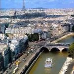
The Thames is over 200 miles long. It flows through the rich agricultural and industrial districts of the country. London, the capital of Great Britain, stands on it. The Thames has a wide mouth, that’s why the big ocean liners can go up to the London port.
Geographical position of Great Britain is rather good as the country lies on the crossways of the see routes from Europe to other parts of the world. The sea connects Britain with most European countries such as Belgium, Holland, Denmark, Norway and some other countries. The main sea route from Europe to America also passes through the English Channel.
Географическое положение Великобритании (3)
Объединенное Королевство Великобритании и Северной Ирландии занимает территорию около 244 тысяч квадратных миль. Оно расположено на Британских островах. Британские острова отделены от Европы проливами Па-де-кале и Ла-Манш. Британские острова омываются Северным морем на востоке и Атлантическим океаном на западе.
Население Великобритании около 60 миллионов. Самые большие города страны — это Лондон, Бирмингем, Ливерпуль, Манчестер, Глазго и Эдинбург.
Территория Великобритании разделена на четыре части: Англию, Шотландию, Уэльс и Северную Ирландию.
Англия находится в южной и центральной части Великобритании. Шотландия — на севере острова. Уэльс находится на западе. Северная Ирландия расположена в северо-восточной части Ирландии.
Англия — самая богатая, плодородная и наиболее населенная часть страны. На севере и на западе Англии есть горы, но вся остальная часть территории — большая равнина. В северо-западной части Англии много красивых озер. Эта часть страны так и называется — Район озер.
Шотландия —- земля гор. Плоскогорье Шотландии — одно из самых древних в мире. Самая высокая гора Великобритании также находится в Шотландии. Цепь гор в Шотландии называется Грампианскими горами. Самая высокая их вершина — Бен Невис. Это самый высокий пик не только в Шотландии, но и в Великобритании. В Англии есть Пеннины. В Уэльсе — Камбрианские горы.
Сегодня на Британских островах нет больших лесов. Самый знаменитый лес — Шервудский, он расположен на востоке Англии, к северу от Лондона. По преданию, это — пристанище Робина Гуда, знаменитого героя легенд.
На. Британских островах много рек, но они не очень длинные. Самая длинная река в Англии — Северн. Она впадает в Ирландское море. Самая главная река Шотландии — Клайд. На ней стоит Глазго. Многие английские и шотландские реки соединены между собой каналами так, чтобы по воде можно было добраться из одного конца Великобритании в другой.
Длина Темзы — более 200 миль. Она течет через богатые сельскохозяйственные и индустриальные районы страны. Лондон, столица Великобритании, стоит на ней. Темза имеет широкое устье, именно поэтому большие океанские лайнеры могут заходить в Лондонский порт.
Географическое положение Великобритании довольно удачно, так как страна лежит на пересечении морских путей из Европы в другие части света. Море соединяет Британию с такими европейскими странами, как Бельгия, Нидерланды, Дания, Норвегия и некоторыми другими странами. Главный морской путь из Европы в Америку также проходит через пролив Ла-Манш.
1. Прослушать произношение слова и перевод на howjsay.com . Направление перевода выберите один раз из списка, в дальнейшем оно сохранится. Для многократного повторения подводите стрелку мышки к выделенному слову в колонке слева.
3. Подробный перевод в словаре Мультитран . (В часы перегрузок Интернета работает медленно, но словарь хороший.)
Топик по английскому языку «The Geographical Position of Great Britain — Географическое положение Великобритании»

The United Kingdom of Great Britain and Northern Ireland covers an area of some 244 thousand square miles. It is situated on the British Isles. The British Isles are separated from Europe by the Strait of Dover and the English Channel. The British Isles are washed by the North Sea in the east and the Atlantic Ocean in the west.
The population of Great Britain is about 60 million. The largest cities of the country are London, Birmingham, Liverpool, Manchester, Glasgow and Edinburgh.
The territory of Great Britain is divided into four parts: England, Scotland, Wales and Northern Ireland.
England is in the southern and central part of Great Britain. Scotland is in the north of the island. Wales is in the west. Northern Ireland is situated in the north-eastern part of Ireland.
England is the richest, the most fertile and most populated part in the country. There are mountains in the north and in the west of England, but all the rest of the territory is a vast plain. In the northwestern part of England there are many beautiful lakes. This part of the country is called Lake District.
Scotland is a land of mountains. The Highlands of Scotland are among the oldest mountains in the world. The highest mountain of Great Britain is in Scotland too. The chain of mountains in Scotland is called the Grampians. Its highest peak is Ben Nevis. It is the highest peak not only in Scotland but in the whole Great Britain as well. In England there is the Pennine Chain. In Wales there are the Cumbrian Mountains.
There are no great forests on the British Isles today. Historically, the most famous forest is Sherwood Forest in the east of England, to the north of London. It was the home of Robin Hood, the famous hero of a number of legends.
The British Isles have many rivers but they are not very long. The longest of the English rivers is the Severn. It flows into the Irish Sea. The most important river of Scotland is the Clyde. Glasgow stands on it. Many of the English and Scottish rivers are joined by canals, so that it is possible to travel by water from one end of Great Britain to the other.
The Thames is over 200 miles long. It flows through the rich agricultural and industrial districts of the country. London, the capital of Great Britain, stands on it. The Thames has a wide mouth, that’s why the big ocean liners can go up to the London port.
Geographical position of Great Britain is rather good as the country lies on the crossways of the see routes from Europe to other parts of the world. The sea connects Britain with most European countries such as Belgium, Holland, Denmark, Norway and some other countries. The main sea route from Europe to America also passes through the English Channel.
Перевод топика: Географическое положение Великобритании
Объединенное Королевство Великобритании и Северной Ирландии занимает территорию около 244 тысяч квадратных миль. Оно расположено на Британских островах. Британские острова отделены от Европы проливами Па-де-кале и Ла-Манш. Британские острова омываются Северным морем на востоке и Атлантическим океаном на западе.
Население Великобритании около 60 миллионов. Самые большие города страны — это Лондон, Бирмингем, Ливерпуль, Манчестер, Глазго и Эдинбург.
Территория Великобритании разделена на четыре части: Англию, Шотландию, Уэльс и Северную Ирландию.
Англия находится в южной и центральной части Великобритании. Шотландия — на севере острова. Уэльс находится на западе. Северная Ирландия расположена в северо-восточной части Ирландии.
Англия — самая богатая, плодородная и наиболее населенная часть страны. На севере и на западе Англии есть горы, но вся остальная часть территории — большая равнина. В северо-западной части Англии много красивых озер. Эта часть страны так и называется — Район озер.
Шотландия —- земля гор. Плоскогорье Шотландии — одно из самых древних в мире. Самая высокая гора Великобритании также находится в Шотландии. Цепь гор в Шотландии называется Грампианскими горами. Самая высокая их вершина — Бен Невис. Это самый высокий пик не только в Шотландии, но и в Великобритании. В Англии есть Пеннины. В Уэльсе — Камбрианские горы.
Сегодня на Британских островах нет больших лесов. Самый знаменитый лес — Шервудский, он расположен на востоке Англии, к северу от Лондона. По преданию, это — пристанище Робина Гуда, знаменитого героя легенд.
На. Британских островах много рек, но они не очень длинные. Самая длинная река в Англии — Северн. Она впадает в Ирландское море. Самая главная река Шотландии — Клайд. На ней стоит Глазго. Многие английские и шотландские реки соединены между собой каналами так, чтобы по воде можно было добраться из одного конца Великобритании в другой.
Длина Темзы — более 200 миль. Она течет через богатые сельскохозяйственные и индустриальные районы страны. Лондон, столица Великобритании, стоит на ней. Темза имеет широкое устье, именно поэтому большие океанские лайнеры могут заходить в Лондонский порт.
Географическое положение Великобритании довольно удачно, так как страна лежит на пересечении морских путей из Европы в другие части света. Море соединяет Британию с такими европейскими странами, как Бельгия, Нидерланды, Дания, Норвегия и некоторыми другими странами. Главный морской путь из Европы в Америку также проходит через пролив Ла-Манш.
Vocabulary:
The Geographical Position of Great Britain — �������������� ��������� �������������� (3), ������ ���� �� ����������� ����� � ���������. �����.
The United Kingdom of Great Britain and Northern Ireland covers an area of some 244 thousand square miles. It is situated on the British Isles. The British Isles are separated from Europe by the Strait of Dover and the English Channel. The British Isles are washed by the North Sea in the east and the Atlantic Ocean in the west.
The population of Great Britain is about 60 million. The largest cities of the country are London, Birmingham, Liverpool, Manchester, Glasgow and Edinburgh.
The territory of Great Britain is divided into four parts: England, Scotland, Wales and Northern Ireland.
England is in the southern and central part of Great Britain. Scotland is in the north of the island. Wales is in the west. Northern Ireland is situated in the north-eastern part of Ireland.
England is the richest, the most fertile and most populated part in the country. There are mountains in the north and in the west of England, but all the rest of the territory is a vast plain. In the northwestern part of England there are many beautiful lakes. This part of the country is called Lake District.
Scotland is a land of mountains. The Highlands of Scotland are among the oldest mountains in the world. The highest mountain of Great Britain is in Scotland too. The chain of mountains in Scotland is called the Grampians. Its highest peak is Ben Nevis. It is the highest peak not only in Scotland but in the whole Great Britain as well. In England there is the Pennine Chain. In Wales there are the Cumbrian Mountains.
There are no great forests on the British Isles today. Historically, the most famous forest is Sherwood Forest in the east of England, to the north of London. It was the home of Robin Hood, the famous hero of a number of legends.
The British Isles have many rivers but they are not very long. The longest of the English rivers is the Severn. It flows into the Irish Sea. The most important river of Scotland is the Clyde. Glasgow stands on it. Many of the English and Scottish rivers are joined by canals, so that it is possible to travel by water from one end of Great Britain to the other.
The Thames is over 200 miles long. It flows through the rich agricultural and industrial districts of the country. London, the capital of Great Britain, stands on it. The Thames has a wide mouth, that’s why the big ocean liners can go up to the London port.
Geographical position of Great Britain is rather good as the country lies on the crossways of the see routes from Europe to other parts of the world. The sea connects Britain with most European countries such as Belgium, Holland, Denmark, Norway and some other countries. The main sea route from Europe to America also passes through the English Channel.
������� ������: The Geographical Position of Great Britain — �������������� ��������� �������������� (3)
The geographical location of Great Britain — Географическое положение Великобритании
Situated in north-western Europe, lying to the north of France and west of the Netherlands (1) and Denmark (2). the United Kingdom, known popularly as Great Britain, is 244,786 sq. km (94,512 sq. miles).
It is situated on the British Isles. There are 5,500 islands. The two main islands are Great Britain and Ireland.
The British Isles are separated from Europe by the Strait of Dover (3) and the English Channel. The British Isles are washed by the North Sea in the East and the Atlantic Ocean in the West.
The territory of Great Britain is divided into Lowland Britain and Highland Britain. Low- land Britain comprises (4) Southern and Eastern England. Highland Britain includes Scotland. Wales, the Pennines and the Lake District.
As well the territory of Great Britain is divided into four parts: England, Scotland, Wales and Northern Ireland. England is in the southern and central part of Great Britain. Scotland is in the north of the island. Wales is in the west. Northern Ireland is situated in the north-eastern part of Ireland.
England is the richest, the most fertile (5) and most populated part in the country. The main territory is a vast plain. In the north-western part of it there are many beautiful lakes. This part is called Lake District, which is an isolated compact mountain group to the west of the Pennines.
Scotland is a land of mountains. The Highlands of Scotland are among the oldest mountains in the world. The chain of mountains in Scotland is called the Grampians (6). Its highest peak is Ben Nevis. In England there is the Pennine (7) Chain. In Wales there are the Cumbrian Mountains.
The British Isles have many rivers but they are not very long. The longest of them is the Severn (8). It flows into the Irish Sea. The most important river in Scotland is the Clyde. Glasgow stands on it. The Thames is the widest river in Great Britain. It is over 200 miles long. It flows through the rich agricultural and industrial areas of the country. London, the capital of Great Britain, is situated on it.
The population of Great Britain is over 56 million. Of every ten people in the United Kingdom, almost eight live in towns, four of them in one of the eight major urban groups.
The Greater London — the largest centre of industry, the most important centre of office employment and the capital city — is the largest of all cities in Great Britain. Other largest cities of the country are: Birmingham, Liverpool, Manchester, Glasgow and Edinburgh.
The flora of the British Isles is much varied and the fauna is similar to that of the north-west of Europe.
England, once ‘the workshop of the world’ (9). was the first to become a highly developed industrial country. The following branches are developed in Britain’s economy: shipbuilding, textile industry, engineering and metal, woollen and cotton manufacturing, coal-mining and light industry.
The country is not very rich in natural resources. With the exception of iron ore, all metallic ores have to be imported.
The small proportion of the total population is engaged in agriculture. The main contributions to British agriculture are from crops (24%), livestock (10) (38%) and horticultural products (11) (11%).
The geographical position of Great Britain is rather good as the country lies on the cross- ways of the sea routes from Europe to other parts of the world.
Расположено в северо-западной Европе, на север от Франции и на запад от Нидерландов и Дании, Объединенное Королевство, более известного как Великобритания, охватывает территорию в 244 786 кв. км. (94 512 кв. миль).
Раскинулась оно на Британских островах, в состав которых входит 5500 маленьких островков и 2 крупные острова: Великобритания и Ирландия.
От Европы Британские острова отделены проливом Па-де-Кале и Ла-Маншем. На Востоке они омываются Северным морем, а на западе — Атлантическим океаном.
Территорию Великобритании можно разделить на низменности и холмами. До первых входят южная и восточная Англия, нагорье же укрывают Шотландию, Валию, переходят в Пенинские горы и достигают района озер.
В состав Великобритании входят: Англия, Шотландия, Валия, Северная Ирландия. Англия является южной и центральной частью Великобритании. Шотландия расположена на севере острова. Валия — на западе, а Северная Ирландия — в северо-восточной части Ирландии.
Англия — это самая богатая, самая плодородная и наиболее заселенная страна. Большинство территории составляет безграничная равнина, на северном западе которой раскинулись прекрасные озера. Эта часть называется озерным краем, на западе обособленное небольшим горным массивом от Пенинских гор.
Шотландия — это страна гор. Шотландское нагорье принадлежит к старейшим горам мира. Цепь гор Шотландии называется Грампианскими горами. Наивысшей точкой Грампианских гор является Бен Невис. В Англии расположены Пенинские горы, а в Валлии — Кембрийские.
Британские острова богаты на реки, которые не выделяются своей протяженности. Самой длинной из них является Северн, что бросается в Ирландское море. Важнейшей рекой Шотландии является Клайд, на берегах которого расположен город Глазго. Темза — самая широкая река Великобритании, длиной 200 миль. Она протекает через богатые сельскохозяйственные и развитые промышленные районы страны. Столица Великобритании, Лондон, расположенная на ее берегах.
Население Великобритании составляет 56 млн. человек. Из каждого десятка жителей Соединенного Королевства около 8-ми проживает в городах, а 4 из них — в одном из восьми мегаполисов.
Большой Лондон — крупнейший промышленный и деловой центр и столица страны больше всех городов
Великобритании. Другими крупнейшими городами Великобритании являются: Бирмингем, Ливерпуль, Манчестер, Глазго, Эдинбург.
Растительный мир Британии в значительной мере отличается от флоры северо-западной Европы, тогда как фауна — имеет немало общего.
Англия, в прошлом «мастерская мира», первой стала высокоразвитой промышленной страной. Хорошо развиты следующие отрасли: судостроение, текстильная промышленность, энергетика и металлургия, шерстяная или хлопчатобумажная обрабатывающая промышленность, угледобывающая и легкая промышленность.
Страна имеет незначительные природные ресурсы. За исключением железной руды, все металлы в Великобританию импортируются.
В сельском хозяйстве задействовано незначительная часть населения. Основную долю британского сельского хозяйства составляют зерновые (24%), поголовье крупного рогатого скота (38%), продукты садоводства (11%).
Географическое положение Великобритании довольно удобно, поскольку страна находится на перекрестке морских путей из Европы в другие части мира.
1. Netherlands [‘neðələndz] — Нидерланды
2. Denmark [‘denmɑːk] — Дания
3. Strait of Dover — пролив Па-де-Кале
4. comprise — включать, охватывать
5. fertile [‘fɜːtaɪl] — плодородная
6. the Pennines — Пеннинские горы
7. the Grampians [‘græmpɪənz] — Грамніанські горы
8. the Severn — p. Северн
9. ‘the workshop of the world’ — «мастерская мира»
10. livestock — поголовье крупного рогатого скота
11. horticultural products — продукты садоводства
1. What is the geographical position of the British Isles?
2. Where is Lake District situated?
3. What are the main chains of mountains in Great Britain?
4. What is the longest river in Great Britain?
5. What advantages does Great Britain have due to its geographical position?